Friday, October 1, 2010

Mt St Helens, Washington Johnston Observatory View

Mt St Helens, Washington, August 2010


We left McChord Air Force Base FamCamp and drove about 140 miles to Silver Cove RV Resort in Silverlake, Wa about 40 miles from Mt St Helens National Volcanic Monument Visitor Center. There are several visitor centers as you travel around the volcano. The first center is located about 45 miles from the Johnston Ridge Observatory, where you first get a view of the mountain and during the day the park rangers offer briefings about what happened in May of 1980. A 15 minute video with actual newscast from local coverage of when it erupted and the aftermath. Several museum type displays are there along with newspaper articles, film clips and a gift shop with many books that were written about that day. We left the center and headed towards the RV resort and set up. Mid afternoon we drove up state route 504 and headed to the Johnston Observatory. Along the way we came across many signs along the road indicating points of interest. First and most interesting was the sign "Entering Blast Zone". This was about, I believe, to be 10-15 miles from the volcano. Trees that were in the direct path of the blast had their tops snapped off or just ripped from their trunks and sent to topple other trees in the blast zone. An example of a tree in the direct path is in the Observatory on display, the force is shown where the top was snapped off.

In June 1987 the Wayerhaeuser Company completed their commitment to replant the forest with a 9 million dollar project to replant some 18.4 million trees by hand one by one with their projected first harvesting in 2010. The project covered some 45,000 acres. When you drive down the road you can see where the controlled plantings took place and where nature started over reforestation.

Again at Johnston they have a 15-20 minute video on the eruption but from a different view and being so close to the volcano once you see the movie you have a better sense of what it was like back then. When you go out on the observation deck you can see the direction of the mud flows and you also have to imagine that this landscape is now 200 feet higher than what is was before the eruption. Trees flowed downstream took out bridges, homes and anything that was in its path. You have a great view of the volcano and can see another volcanic dome that has been growing over the years and see the ash dust that keeps sliding down from the top of the mountain and creating landslides in the crater. Ash dust flies all the time and these landslides inside the crater cause the elevation to rise about 150 feet a year. The day we visited the wind must have been around 35-40 mph. From this view point you could see Mt Adams which is still snow covered as well as Mt Rainier.

This National Monument is a work in progress as the mountain is still being monitored and according to the park rangers, a lot has been learned on predicting eruptions. They share their lessons learned with other countries - one of the largest classrooms we have ever seen. On our way out of the park we stopped at another center where you can take helicopter rides to the top of the mountain and into the crater, you don't stop you just do a fly by. We weren't ready for that adventure but it did sound like it could have been interesting. At this center we did see a car that was recovered from the blast zone from a local TV station. The reporter was safe but the car did sustain much damage. I will post more pictures on the next travel day. After the eruption, search and rescue operations started and all people who knew the area came back and saw that the landscape they knew was gone and it was all strange to them. No landmarks, roads, rivers, buildings just a complete wasteland. Many new lakes were formed with the landscape changes. The death count was 50 and 60, with some never to be found. Complete families, reporters, scientist and just people that shouldn't have been there.


Our first day of travel in the park was so very interesting and does give you a wake up call, especially when you look at the Volcano. To me it looked like it had a smirk on its face to tell people that I am still here and don't try to wake me up again. I can be some ugly.
Our next stop was Windy Ridge View Point.


Sunday, September 26, 2010

Seattle's Pike Public Market

Our trip from Deadwood, SD took us across Montana and then into Washington. We got about 80 miles east of Seattle on I-90 and found that the road conditions were very rough for an interstate highway. For a while I was worried that the fillings in my teeth were going to be shaken out of place. The conditions lasted all the way into Seattle and then on I 5 south was just as bad for about 40 more miles. We stopped for a couple of nights at McChord Air Force Base FamCamp. Nice campground, great price the only problem is that it is in the middle of a red wood forest so that eliminated the use of our satellite dish and problems with our Internet connection. We had to rough it for a couple of nights.

We had heard so much about Seattle that it was one of those places you have to see. We made our way into town the next morning and found that we couldn't get out of town fast enough. We made it to Pike's Public Market on the waterfront and walk the area. We spent a couple of hours there and headed back to the base. Road conditions, traffic and road construction and talking with locals is that you only have a few hours to enjoy the city as heavy traffic runs till after 9 and starts again around 2 pm, so that does not give much time for sight seeing. We come to the conclusion that we like the country settings, State and National Parks and just enjoying the quieter things in life.

Our next journey to this area will be better planned so that we will visit Olympic National Park and stay out of the big city.


Wednesday, September 22, 2010

Kool Deadwood Nights Concert

Downtown Main Street turned into a concert with a party atmosphere. Budweiser was a major sponsor along with all the local casinos and bars. Special celebration glasses were sold for around $5 and refilled depending on what brand of beer your were drinking for between 2.50 and 3.50 and you could walk the downtown section till 10 pm each night. What was surprising to us was the lack of visibility of the local police only 3 officers were on foot patrol the whole day and night. The crowd was estimated to be between 10000 and 15000 both nights and where all the people went to after the concerts we don't know as we had to drive out of town back to the RV park about 6 miles away. We did not encounter any traffic problems. There is not that many hotel rooms in this town and the population is around 1300 people in Deadwood and around 1400 for Lead a couple of miles away.


Friday night concert featured "Sha Na Na" and on Saturday "The Platters". Concerts were opened with local bands.


This was a great spot to visit. Located in the Black Hills of South Dakota and surrounded by loads of history and fun.

While we there we had to make another visit to Mt Rushmore about 40 miles away, still an amazing National Monument.


This what Main Street looked like around 4 pm before the concerts. Crowd estimated between 10 and 15k.


Kool Deadwood Nights Classic Cars

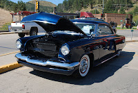
Here is just a small sample of the cars that were at "Kool Deadwood Nights". There was over 700 on display and some were for sale at the auction.


1966 Mustang


1933 Ford Cabriolet


1933 Lincoln


1938 Chevy Coupe
For sale asking $80,000 yes 80K


1948 Ford


1957 Chevy (look who is in driver seat)


And this one feels so good.


1948 Buick Convertible


1940 Ford


Check out the air cleaner, an old tea kettle.


Thursday, September 16, 2010

Deadwood, South Dakota Aug 2010

During the past 3 years of travel, Sue and I have come across some interesting spots in this country of our. This time we arrived in Lead / Deadwood, South Dakota. These two towns have so much history in their 130 years of existence. There is a lot of activity going on year round in this area. In Deadwood at the Fire Hall there is a memorial dedicated to the Firefighters, past, present and future.


Deadwood Fire Hall


First In Last Out Firefighter Memorial


Downtown Deadwood is pretty much the same in appearance as it was in the early 1900's, storefronts with apartments upstairs and hotels. Today the storefronts are now casinos and the hotels are hotels with casinos and restaurants. What appeared to be apartments above the storefronts were actually brothels that ran up until the 1980's. Today as you walk the main street you will see mannequins in the windows dressed up as they did when they were in business. Colonel George Armstrong Custer led and expedition to the Black Hills and then announced the discovery of Gold and caused the Black Hills Gold Rush and from there the town went lawless and the population raised to almost 5000. Today it is around 1300 people.


Deadwood is also known for where Wild Bill Hickok was shot in the back while playing a game of five card draw and holding the famous "Dead Man's Hand" of aces and eights. He was shot by Jack McCall and was later tried and convicted and hung for killing Wild Bill Hickok. He was buried in the town cemetery as well as the famous Calamity Jane. In front of the "Original Saloon #10 there is a sign stating this is where the shooting took place and a few doors up the street there is another sign where they captured the assassin Jack McCall. At the Masonic Building during the summer months they have a re-creation of the trial of McCall every weekend.


The Chamber of Commerce sponsors many activities during the year. The week we visited, it was "Kool Deadwood Nights" with a classic car auction and car show with over 700 cars on display some for sale and most for show. The main street is turned into a outdoor concert theater where you place your chairs on the street anytime after 11 am and the concerts start at 5 pm. On Friday night "Sha Na Na" was the featured act with two local bands to open and on Saturday "The Platters" performed along with 2 other acts. Both concerts had an estimated crowd of over 10,000 to 15,000.


I will post pictures of some of the cars on another blog soon.


Bullock Hotel and Casino
(Hotel has been featured on "Watch Ghost Adventures" on TV as it has been reported as being haunted)


Original Saloon #10 where Wild Bill Hickok was shot in the back.


Statue in front of the 4 Aces Casino of Wild Bill Hickok


Location where Jack McCall was captured.


.


Main street mostly casinos with a few hotels.


Upstairs of storefronts that were actually brothels until 1980's. The mannequins in the windows are in their business dress of the times. This is just 2 windows but there must be at least 12 windows that in display. Just part of the history.


Wednesday, September 15, 2010

Geographical center of the Nation, Belle Fourche, SD

We left Wendy and Troy on the 23 of August and headed to South Dakota and arrived in Lead/Deadwood on the 24th, where we met up with friends from NH, Bob and Jeanne Cooper and had a great time with them. Lead/Deadwood has a lot of history about gold mines, the wild west and today with gambling. What we found out about these 2 towns is that there is always something going on. This week was "Kool Deadwood Nights" with a classic car show and auction with over 700 classic cars on display and many up for sale, this activity was put on by the Chamber of Commerce. We will have more on the "Kool Deadwood Nights" on our next update.


During the week we traveled around the area checking out the tourist items of interest. We drove about 25 miles to a town of Belle Fourche, SD which is known as the "Geographical Center of the Nation". Prior to Alaska and Hawaii becoming states the center was located in Kansas and later moved here. In town there is a visitor center with a "Tourist ceremonial center of the nation" with a walkway of state flags and their "Center of the Nation" display. The actual Center of the Nation is located about 20 miles outside Belle Fourche along a dirt road in the pasture. An American Flag flies at the location. When we found out where the actual site was we were told to watch out for rattle snakes, and in reality our biggest concern walking was the cow patties laying all over the place. When we got to the site at the base of the flag pole was a US Survey Marker #1 dated 1962. There was not much decoration or fanfare for this site. Of course we had to take pictures of ourselves being at the center. This whole area offers a lot in history and site seeing. Wish we had planned ahead to see more. We traveled over to Rapid City then to Keystone and then back to Mt Rushmore. It is still one of our favorite sites to see.